
Imagine a family taking a walk at the beginning of the 20th century through our Parish. Would our family recognise the area today? What changes would they see?
They would have walked through a mostly rural landscape and would have seen evidence of industry. Mining, railways and iron works all major employers of labour and the reason why people were drawn to this area. Housing was often of a colliery terrace nature, concentrated on main roads and surrounded by fields.
Most of this part of Durham was rural before the suburbs started to swallow up agricultural land. However in 1900 there was considerable industrial presence in the area. New mines were sunk and old ones closed, and this added to the precarious nature of a miner’s employment in the 19th century. These included, Kepier Colliery (situated few yards North of Sunderland Road) Grange Colliery (now a caravan park near A1M junction 62), Kepier Grange Colliery (situated in what is now Belmont Industrial Estate), and Broomside Colliery which closed in 1890. But the most important industrial works by far was the Grange Iron Works, which in its heyday was the most important industrial establishment in the neighbourhood of Durham. By 1916 it would be receiving orders from Australia, New Zealand, South Africa, China, Brazil, India and other parts of the world.
We start at the crossroads in Gilesgate Moor. Here is the Hare and Hounds public house. Today this is a Veterinary Surgery and in 1900 our family would have seen the Grange Foundry Inn, only recently demolished, walked past a street named Bell’s Villa and seen more open fields and countryside. North of Sunderland Road was High Grange Farm. ‘Grange’ is the mediaeval word for an outlying farm or granary. In the 1960s this land was sold to William Leech and he built a housing estate named High Grange Estate.
Walking through Gilesgate Moor the family would have open countryside on their left and a row of houses where Marshall Terrace is today. On to the Traveller’s Rest and on the opposite side a row called Eden Villa. We continue on past the Forester’s Arms, Alma Place and into Belmont and Carrville. Between High Grange and Moor End Belmont, today we have a Retail Park, Moorfield Park and a bridge over the A1M motorway. What would our 1900 family have made of these transport links – in 1900 a car would have been a rare sight and the railway, horses, carts and walking was the way to get around. A large area of farmland, south of Sunderland Road near Renny’s Lane was called Ravens Flatt. Flatts were medieval field divisions and today much of this is occupied by the Dragonville Industrial estate.
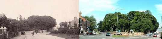
We enter Belmont at the descriptively named Moor End. This is the end of Gilesgate Moor and we see the handsome Church of St Mary Magdalene consecrated in 1857, designed by William Butterfield and a listed building. Richard Pemberton of Belmont Hall gave the land for the church. Industrial development meant that a new parish was needed and in 1852 Belmont Parish was formed from St Giles.
Blue House which we still see today opposite the church, now a block of shops was a farm and today near the church we see the War Memorial. This commemorates those who gave their lives in World War 1 and World War 2 and more recent conflicts. The churchyard also has graves of World War 1 soldiers as well as those who died in pit accidents. The Memorial was originally sited in the churchyard but was moved in 2009 to its present position. Of course in 1900 there would have been no War Memorial – the conflicts of the 20th Century were still to come.
The west side of Carrville High Street was occupied by terraced streets with open fields behind them. Plans show allotments behind the High Street which miners kept to supplement their incomes. Broomside Lane had a number of short rows of houses again with open field around them. The Vicarage and school were also in Broomside. The education act of 1870 saw the first state school open in here. Three teachers taught up to 200 children. However their attendance was a problem as some families could not afford to send their children to school. In 1900 a water supply arrived at the school. Children would have to wait until 1913 for the installation of water closets for girls. The boys had to wait until 1922.
Nonconformists also had their own places of worship in the area. There was a Wesleyan Methodist chapel in Bainbridge Street and a Primitive Methodist Chapel at 40 High Street. During the Methodist Revival in the 19th century the Wesleyan Methodists built new premises on the High Street. This building served them for 120 years and in 2004 a new church was completed.
At the end of the High street our family would have walked on to Belmont Railway Station, which by 1900 was only handling goods and opposite would have looked at the prosperous estate of Belmont Hall after which the station was named.
Many of the inhabitants of Belmont worked on the railways in 1900 and three major lines ran through the area. Belmont Station was opened in 1844 at the junction of the ‘old main line’ and the short branch line into Durham at Gilesgate. Incredibly as it may seem today all passengers to and from the City were required to change trains at Belmont as all main line trains by-passed the city. By 1900 there were no passenger trains as this was closed in 1857 when the station and viaduct at Durham were built, although Durham would not be on the main line until 1871. Belmont station closed in 1966 and all the property has been demolished. Today our family would see in this area, the Park and Ride Site which opened in December 2005 and provides a convenient link with the shops and attractions in the city.
In 1820 Thomas Pemberton demolished an old hall and built a new home which he called Belmont Hall. In 1900 John S G Pemberton lived there. He was MP for Sunderland where the family had many connections. In the 1960s when the family sold the estate it reverted to its original name of Ramside Hall. When the Parish of Belmont was formed in 1852 from Pittington and Gilesgate Parish, and the church was built on land donated from the Pemberton estate the area took the name Belmont.
* Copyright Margaret Pattinson, A Trip Through Time, September 2011
Useful Websites
If you’d like to find out more about the history of Belmont then the following websites should prove useful: